October 2025 is off to a dramatic start in the weather world. Sprawling Atlantic storms have formed just off the U.S. southeastern seaboard, while intense heat grips parts of Texas, raising concerns about public safety, erosion, and fire hazards. Together, these conditions remind us how interconnected global weather is—and how even storms far at sea can affect coastal and inland environments.
Imelda, Humberto: Tropical Systems Brewing
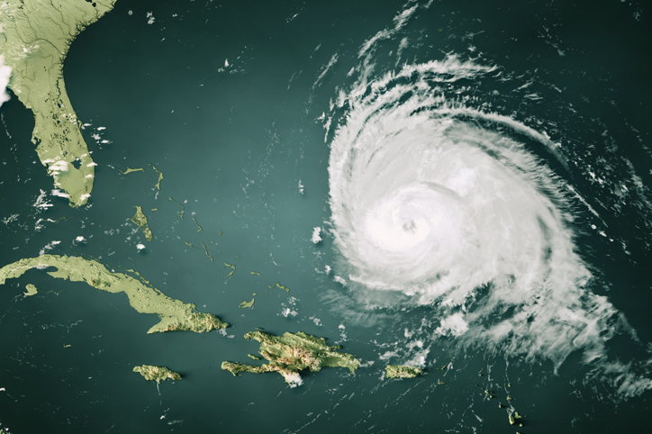
Two significant storms—Hurricane Humberto and Tropical Storm Imelda—are swirling in the Atlantic. Humberto, currently a Category 2 storm, is positioned west of Bermuda with winds near 100 mph. Forecasts suggest it may skirt Bermuda, bringing strong winds and dangerous surf.
Meanwhile, Tropical Storm Imelda formed over the Bahamas and is expected to strengthen into a hurricane. While its core is projected to pull away from the U.S., its peripheral impacts (like elevated seas, rip currents, and localized heavy rainfall) are still concerns for the Bahamas, Cuba, and coastal communities along Florida through the Carolinas.
Even though direct landfall in the U.S. is now considered unlikely, forecasters warn that coastal areas should remain alert because tropical storms often have unpredictable shifts in path. Marine warnings are in effect in places expecting rough surf and dangerous rip currents.
Heat, Dry Air, and Wildfire Risk in Texas
On the other side of the map, Houston, Texas is enduring abnormal heat. Temperatures in the mid-90s have persisted into late September—and forecasts suggest this heat will carry into early October. The heat is arriving with unusually low humidity (dropping below about 35%) and drier soil conditions, raising concerns about wildfire danger, especially in regions that already experienced dry spells.
Local authorities are alert, advising residents to take simple precautions: stay hydrated, avoid strenuous outdoor activity during peak heat hours, and be aware of fire risk when using equipment or having open flames. Because vegetation is dry and more flammable, even small sparks or dry debris can lead to serious brush fires.
What to Watch in the Coming Weeks
As October unfolds, several things merit attention:
Storm path shifts: Imelda and Humberto may change course more than currently projected, especially if steering patterns in the Atlantic shift. Even small changes in track can lead to significant impacts on weather and coastal conditions.
Coastal flooding and rip currents: With seas elevated by these storms, coastal areas could see flooding or dangerous surf conditions—even without direct storm landfalls.
Wildfire potential in Texas: If heat continues and rainfall remains sparse, Texas and other southern states may see escalated wildfire risk. Soil dryness, drought conditions, and persistent heat all contribute.
Public health & infrastructure stress: Heat waves and storm-related moisture (or lack thereof) stress power grids, water supplies, and emergency services. Vulnerable populations (elderly, those with breathing or cardiovascular problems) may be especially at risk.
Bottom Line
October 2025 serves as a reminder that weather extremes are rarely isolated—they cascade across regions. Atlantic storms may stay offshore, but their influence reaches land in surf, flooding risks, and shifting sea conditions. Meanwhile, in Texas, the heat isn’t letting up, bringing fire danger and stress alongside it.
Even if direct impacts are avoided, lingering effects—coastal erosion, elevated fire risk, emergency prep—underscore the need to stay vigilant, informed, and prepared for whatever storms and heatwaves the rest of this fall may bring.


